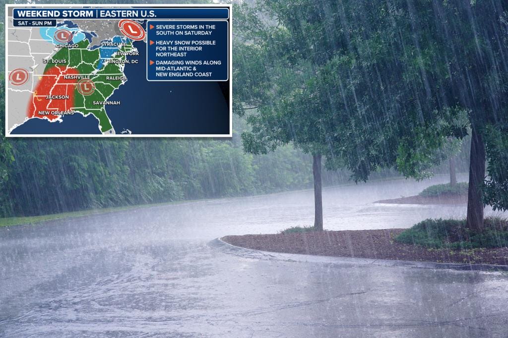
A developing storm system will bring widespread rain, damaging winds, severe thunderstorms and even snow to the eastern half of the United States this weekend.
“While there are still a couple things to figure out weather-wise, it will get it all done,” said Fox Weather meteorologist Britta Merwin. “But it all comes down to location and timing.”
The Fox Forecast Center expects a fairly disruptive storm that will affect millions of Americans, creating travel problems and causing power outages along the East Coast.
“A December weekend with travel and Atlanta is right in the crosshairs,” Merwin said. “You can do the math on that.”
This comes as a trough of low pressure exits the western US on Friday, triggering the development of a shallow trough over the central plains. This initial low will kick off the event with widespread rain and some snow in the Upper Midwest on Saturday, the Fox Forecast Center said.
Heavy and widespread rain will spread through the east
A broad area of moderate to heavy rain is likely to develop from the Gulf Coast to the Great Lakes and eastward toward the East Coast beginning Friday.
Flash flooding will be a concern along the Gulf Coast to parts of central Mississippi and the lower Ohio valleys on Saturday, while the threat moves east from the Florida Panhandle to the mid-Atlantic and much of northeast on Sunday.
The quick movement of this system will help limit rainfall totals. However, significant moisture and sufficient instability should still support rainfall rates high enough to raise some flooding concerns, the Fox Forecast Center said.
Rain, winds and snow are coming to the East Coast this weekend. FOX Weather
Dangerously strong winds will hit on Sunday and Monday
Gusty winds are likely to develop over parts of the Rocky Mountains and Plains on Saturday due to the marked pressure difference between a wavy cold front and strong high pressure over the Interior West. Gusts of between 30 and 40 mph are expected in these areas.
Strong winds are expected to develop along the mid-Atlantic and New England coasts on Sunday and perhaps into Monday, with gusts of 50 to 70 mph possible near the coast.
These wind speeds could be high enough to create major travel problems at major airports over the weekend, and power outages are possible in several states.
Snow expected in Great Lakes and interior Northeast
Some snow may fall on the northwest side of the low from the north-central Plains and Midwest to the Great Lakes on Saturday, but details remain uncertain, the Fox Forecast Center said. Some snow could also fall. of snow after the system passes, primarily over the Great Lakes and Appalachians.
There are signs that colder air arriving behind the storm Sunday night could lead to a flurry of heavy snow in the interior Northeast.
Snow accumulation is increasingly likely in parts of upstate New York, Pennsylvania, Vermont, New Hampshire and Maine for some period of time. However, the Fox Forecast Center clarifies that, at the moment, it is difficult to predict exactly where, when and how much snow will fall.
Flash flooding will be a concern along the Gulf Coast to parts of the central Mississippi and lower Ohio valleys. Romolo Tavani – stock.adobe.com
“Corridor 95 is a failure if you like snow. He’s a pro if you like the 60s, but he will come in the rain,” Merwin said. “On Sunday, although it will be mild, you will be inside your house. Sunday night we started to cool things down, but still above freezing in the 95 corridor.”
Severe climate threat in the south
This storm will also bring the potential for severe weather to the south.
The Fox Forecast Center said some severe storms are possible Friday night in parts of the Ark-La-Tex region and near the Ozarks as moisture flows in from the Gulf of Mexico.
By Saturday, with sufficient moisture and strong wind shear (the change in wind speed and direction with height), a more substantial threat of severe thunderstorms could materialize. Tornadoes, damaging winds, and large hail are possible from eastern Texas to Louisiana, Arkansas, western Mississippi, and western Tennessee.
There is also the threat of adverse weather conditions in the south. nd700 – stock.adobe.com
“We probably won’t see that traditional supercell development,” Merwin emphasized. “But when you have a line of thunderstorms and you’re primarily tracking a wind threat, sometimes we can have these rapidly spinning tornadoes along that line. And those are clever. “They happen fast.”
It appears there will still be some threat for severe weather as the overall system moves further east on Sunday, according to the Fox Forecast Center. Computer forecast models suggest that from the central and eastern Carolinas to the Delmarva Peninsula could be at risk for some strong or severe storms.
Categories: Trending
Source: vtt.edu.vn
